Roadmaps To Our Past
by Collins (CE) Wynn
 The University of Alabama has an intriguing collection of Alabama maps available on line and I’ve spent a little time over the past few weeks reading and studying some of the earlier editions. It has been an interesting experience. In a variety of emails and other correspondence, some of my neighborhood friends and I have talked about Dallas-Rison, Darwin Downs, the Big Ditch, and other parts of our old neighborhoods. My review of these maps revealed some little known (at least to me) facts about old Huntsville. Perhaps visitors to the Rison-Dallas website would enjoy a quick look at this information. I was not previously aware of most of these entries.
In 1837
a. The name of the settlement atop Monte Sano Mountain was “Viduta”. Evidently it was a complete community and had no connection to Huntsville other than proximity. Additional research via the web furnished the following information as well.
Historic Viduta
"Viduta"-derived from Spanish "vida" meaning "life". In a time when yellow fever, malaria, and cholera threatened, Dr. Thomas Fearn and his brothers Robert and George were drawn by the cool air and medicinal springs to establish a small colony on the northern section of Monte Sano Mountain in 1827. In 1833 the town of Viduta was officially established. This area contains a variety of architectural styles dating from the late 1800's. Preston Yeatman was one of the earlier settlers of Huntsville, having come here about the time of Leroy Pope. (bef.1820). Yeatman was a merchant, builder, dealer in property, member of the city government and industrialist. He owned a store in 1820 known as Yeatman and company, dealing in hats, clothes, accessories, and food delicacies. The year 1833 saw the rise of the village of Viduta, on Monte Sano, the little town planned back in 1814. One of its founders was Preston. He was one of the owners of the first cotton mills in the USA, known as Bell Factory.
b. Although it was undeveloped and would remain so for many years, the area we now know as Darwin Downs just to the east of Dallas-Rison was then called as “Bonavista”.
In 1875
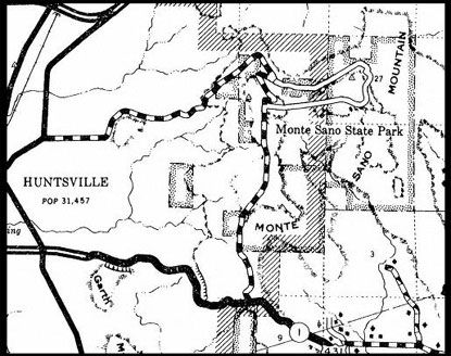
a. Big Cove Pike (later known as Big Cove Road) appears on the 1875 map crossing the mountain but it is not connected to the community on top of the mountain.
b. Bankhead Parkway is identified as Monte Sano Pike and is the only way to and from the community of Viduta.
c. The map has an entry “US Barracks” and drawings indicating tents implying an Army Camp is located on the south side of Oakwood Avenue near the intersection with current day Maysville Road. Perhaps this is the occupation army from the Civil War.
d. The name “Bonavista” is gone from the map.
In 1909
a. Viduta is still there and there remains only one way up and down the mountain.
b. Dallas, Merrimac, and West Huntsville appear as separate communities.
c. The eastern part of Dallas is referred to as “Fairview” (this is the only entry for Fairview I could find).
d. Most of the land now known as Chapman Heights and Darwin Downs is owned by three ladies: Mrs. E. Matthews; Mrs. Julia W. Anderson; Mrs. R. L. Chapman.
e. The “US Barracks” are gone. Evidently the Federals had subdued the local populace by now and departed the area.
In 1937
a. The map still shows Viduta and now includes Monte Sano State Park and the CCC Camp that housed the workers who built the park. The top of the mountain is now connected around Round Top to Big Cove Road so there are two ways up and down.
In 1948
a. The name “Viduta” does not appear on the map and is to never return. Perhaps some of our Monte Sano readers can explain.
b. Huntsville population is shown as 16,437 plus the four mill villages that are shown as individual communities: West Huntsville (or Lowe Mill) 5,500; Huntsville Manufacturing (or Merrimac) 1,100; Lincoln 4,000; and Dallas 2,500 (which also settles the argument of which was larger – Dallas or Lincoln).
In 1959
a. Memorial Parkway appears. As side note, my Dad once told me that even in the 1930’s a trip to town (i.e., Huntsville) and return home from Big Cove, Hampton Cove, New Hope, etc. was a very big deal and an all day event which is why he and his family crossed the mountain as few times as possible. At the time Big Cove was truly the “hinterlands” of Madison County – my Dad told me he had never seen a telephone until he walked (yes, walked) over the mountain in 1939 to join the Army and leave hard scrabble farming behind forever.
The address for the website is http://alabamamaps.ua.edu.
Tommy Towery of www.leestraveller.com contributed to this article.
Return to the Rison-Dallas History Page.