(Click here for a larger version of the map)
Over the years I have become increasingly intrigued with the early history of Huntsville and Madison County. I thought I was well informed on our neighborhood history but that has proven not to be the case. Some of the journeys down memory lane prompted by our Rison-Dallas website have piqued a good bit of my curiosity. For example, for several years I had an on-line running conversation with Tommy Towery, the editor of the on-line newsletter - Lee's Traveller, discussing the source of the name for Lee Highway; our own Lee High School; and our school trademark gym painting and the name of "Lee Generals." Most things I learned from those internet conversations were news to me.
Since then, during quiet moments from time to time, I often wonder what our neighborhood area was like before our homes and schools were there. I have found myself doing searches for maps and other documents and have even written a few articles for the Rison-Dallas website on the same subject.
As a part of those efforts I stumbled on the map archives of the University of Alabama. They have a tremendous library of maps and a history buff can spend hour upon hour just scanning the content. I have looked at all the maps available involving Madison County and Huntsville and several pieces of information have caught my eye over the years. For one, a map of the time shows a US Army Camp in 1875 or so located in the southeast corner of Oakwood Avenue and Maysville Road. I'm sure that is true but I wonder why it would not be common knowledge or why there are no historical markers. With a date of 1875, whatever force there must have been a part of the Federal occupation army. Since Huntsville was an occupied city, it is reasonable to assume many hard feelings remained long after the war which might explain the lack of local lore. My own family had many stories to tell: one grandfather wounded in Tennessee, captured and held for 2 years in a military prison in Indiana; and another grandfather, a civilian, murdered by Federal troops on his farm in Big Cove - but those are stories for another time.
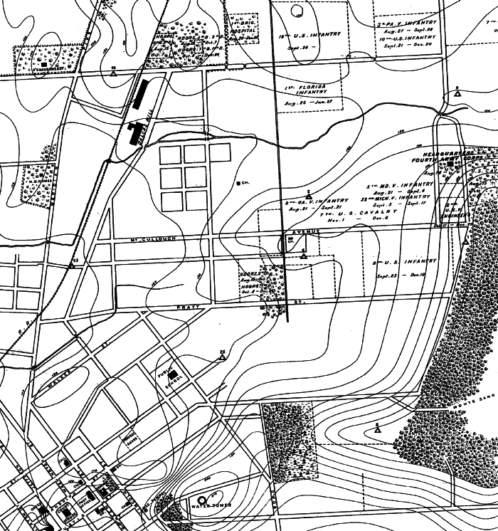
As interesting as all that is, I was completely taken aback by another map I recently discovered. This one is from 1898 and documents the stay of a large military force in Huntsville during that year. The tie to Rison-Dallas is that part of the force was quartered where Rison School once was with another part where Optimist Park now is. I could not download the map electronically so I ordered a paper copy from the University, then took the paper map to an architectural printing firm and had it down loaded to a CD as a PDF file so I could share it with everyone. The map is quite large so I have cropped out the portion dealing with our neighborhood and have included it here. There is much more I could say but I'll stop now and see if anyone has comments. Please note the comment "Old US Barracks" on the map - do you think it might be referring to the 1875 bivouac site - if so, one of the two descriptions is off by ˝ mile or so.
My friend, Rainer Klauss, sent me an article he had written about our area which discusses some of the same times and events. I have also seen old photographs of soldiers standing in formation on the Courthouse Square from the same time period. Apparently, these soldiers were in Huntsville for recuperation after returning from Mexico or wherever they were assigned.
If you look down to the center of the map you will see the portion involving most of Rison-Dallas and Five Points down to Maple Hill Cemetery. Although I did not say so beforehand, the US Army command involved was the Fourth Army Corps and the dates described in the map legend state "Fall of 1898" which means some of the units would have spent the Christmas holidays here and departed in the spring of 1899 based on some of the dates listed near the units. If you look closely you will see the map shows the Corps Headquarters to be in the mansion, "Bide-A-Wee,"? on the east side of Maysville Road a little north of McCullough Avenue (I once knew the building to house a church and have talked about playing football on the grounds as a young boy). Also a number of units appear as being housed in the Five Points area when there were only 4 points in that California Street had not yet been extended to add the 5th point to the intersection.
Two things caught my eye when looking at this section. 1) Maple Hill Cemetery is only a fraction of the size it is today (which is not surprising, I suppose); and , 2) the public school designation looks to me to be East Clinton School since this was 10 years before the birth of Huntsville High School nearby which would make East Clinton the oldest public school in Huntsville.
What do you think about all of the commotion that must have occurred during this time? An Army Corps is large by any standard and it would have had many men, many more horses and pack animals along with tons of supplies and equipment. Since they would have moved by rail at the time it must have really been a sight to the community. It would have certainly brought life to a sleepy southern town.